Images
Videos
Project
Stefano Boeri Achitetti
Location
Valdinievole, Italy
Year
2022- ongoing
Client
FONDAZIONE CARIPT
Typology
Masterplan,Territorial Strategy, Planning, Landscape Enhancement
Services
Masterplan, Strategic guidelines
Stefano Boeri Architetti
Founding Partner: Stefano Boeri
Director: Corrado Longa
Design team: Anna Maiello, Laura Di Donfrancesco, Geronimo Felici Fioravanti, Maria Chiara Negri da Oleggio, Gabriela Cunha Mattei
Consultant:
Monia Guarino (Principi Attivi Bologna)
Lorenzo Mazzali (Visual Identity)
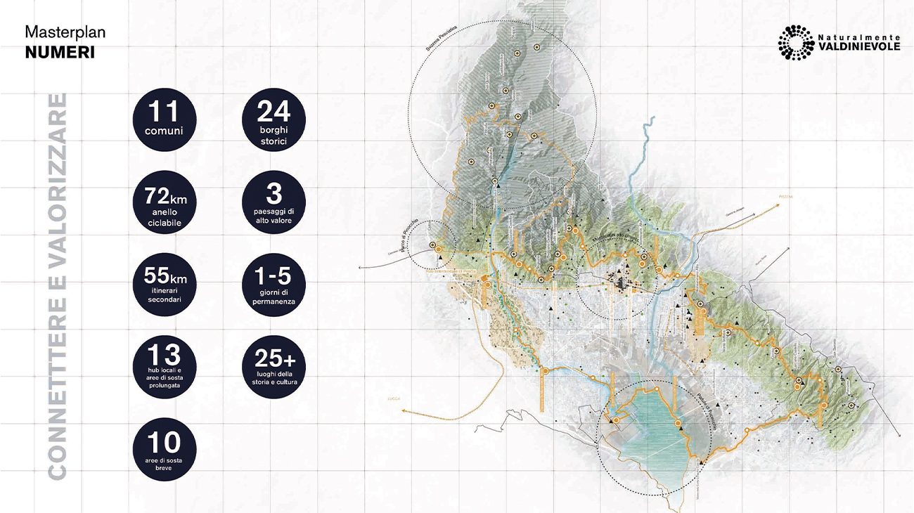
Valdinievole is the territory between the provinces of Pistoia, Florence, Lucca and Pisa, administratively divided into 11 municipalities. Covering more than 260 square kilometres, with a population of about 120,000 inhabitants, the Valdinievole area is characterised by common elements in terms of history, landscape, economy and infrastructure, with a majority of agricultural areas and natural and wooded areas – while urbanised areas occupy less than a quarter of the territory.
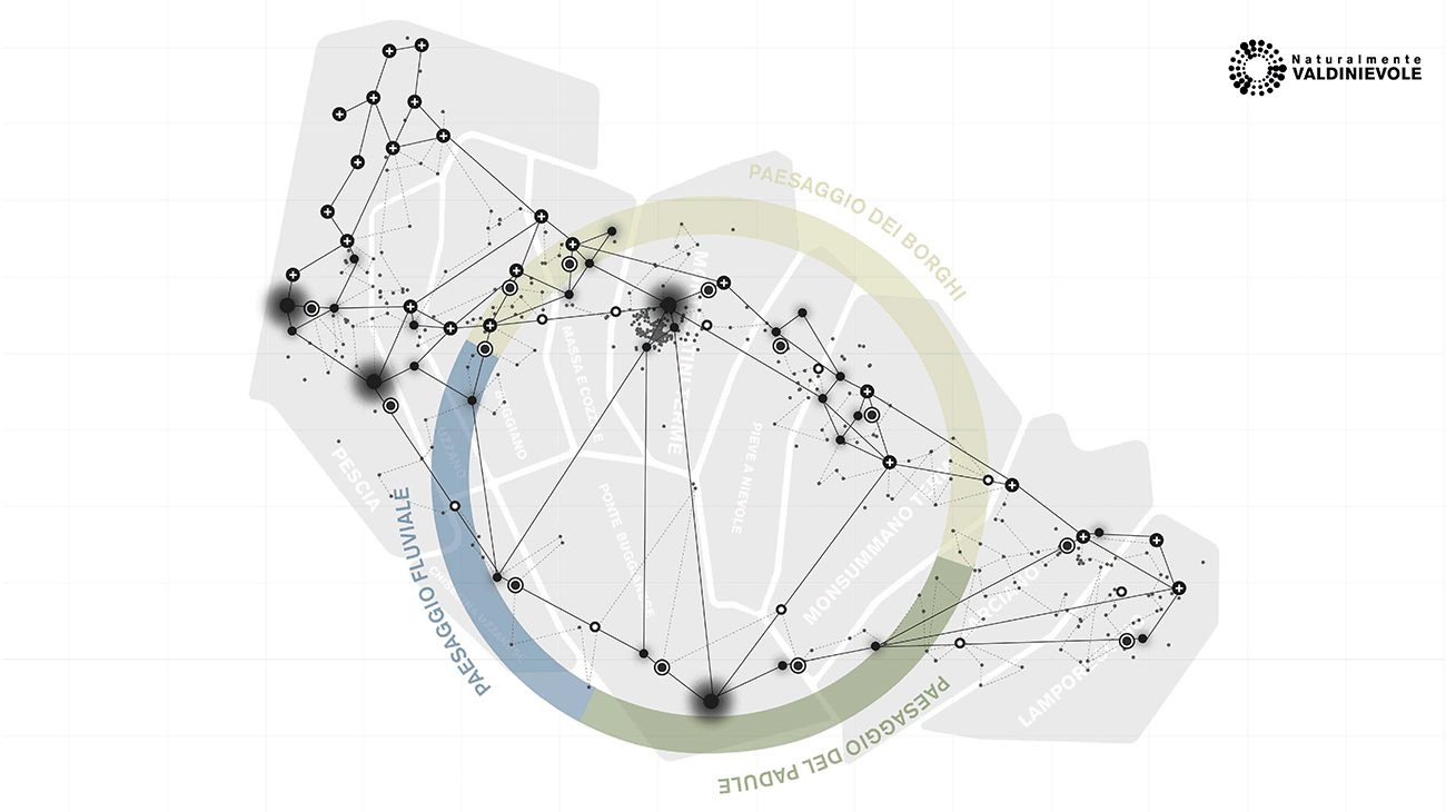
In the constellation of the 22 historic villages it is possible to distinguish some supra-local polarities such as the Pinocchio Park, the UNESCO site of Montecatini Terme and some local polarities such as the international airport of Pisa and the agricultural plain that surrounds the largest Italian inland marshland, the Padule di Fucecchio.
Stefano Boeri Architetti‘s proposal for the redevelopment and valorisation of the Valdinievole, commissioned by Fondazione Caript, fits into this context. Starting from the territory’s criticalities and potentialities, the project aims at outlining a common strategic perspective for the area, which would systemise polarities, excellences and landscapes from the physical, social, environmental and energy points of view.
As far as slow and sustainable mobility is concerned, the Valdinievole is traversed by approximately 180 km of paths that cross the hillside villages and lead down to the Padule di Fucecchio, which to date are poorly maintained and irregular. Improvement of the inter-municipal road network and enhancement of the soft mobility networks, with the systemisation of all the paths, are the primary objectives of Stefano Boeri Architetti’s vision, with the aim of creating a 72 km cycling ring that is structured on the existing paths and connects them in a single physical device across the landscape. The cycling ring connects and activates the existing polarities, enhancing all the municipalities of the Valdinievole valley as an alternative element to traditional mobility serving the inhabitants.
The strengthening of mobility also concerns the railway network, with the duplication of the line (60% of the section is currently on single track) and road mobility, with roads connecting the municipalities, decongesting the main routes to urban centres.
Geographically, the Valdinievole is characterised by a diversified landscape ranging from the sub-mountainous landscape of the high valleys of the Nievole, Pescia and Pescia di Collodi streams, to the hills and foothills of the northern arc of Montalbano, to the reclaimed and marshy plains around the Padule di Fucecchio.
The terraced hillsides cultivated with olive trees are a garrison for the territory and represent 1/3 of the agricultural landscape, of which 3% is occupied by greenhouses mainly used for floriculture and partly disused.
Once again, the valorisation of the existing territorial centralities is the primary objective of the vision for the redevelopment of the Valdinievole, with the optimisation of olive terraces as the territory’s excellence, together with the promotion of the Padule di Fucecchio Protected Area, and the productive enhancement of under-utilised sector activities, which can represent an opportunity to rethink the existing system in terms of innovation, sustainability and increased biodiversity. Finally, abandoned agricultural and floricultural land is recovered with a view to de-impermeabilisation of the natural areas.
The reactivation, enhancement and connection of services and polarities also concerns the infrastructures present in the Tuscan provinces, with the aim of promoting the territory through a digital, innovative and accessible infrastructure. The main interventions concern the reactivation of the Montecatini Terme, the recovery of the Pescia Flower Market – to be redeveloped –, the upgrading of the Pescia hospital, as well as the promotion of a network of sports facilities of supra-local interest (stadiums, golf clubs, tennis clubs, swimming pools, sports halls, etc.) and of technical and professional schools that, put in system with businesses, can activate synergies useful to the territory.
Stefano Boeri Architetti’s project for the Valdinievole is therefore a device of social connectivity, by networking local services and resources; of physical connectivity, thanks to the creation of a cycle and sustainable infrastructure; and of cultural and technological connectivity, by enhancing the existing heritage and favoring the development of energy communities and the implementation of renewable and sustainable production systems, useful to make the territory self-sufficient in terms of energy production.
The numbers of the Plan
11 municipalities
118,658 inhabitants (2022 data)
72 km of cycle path
55 km of secondary routes
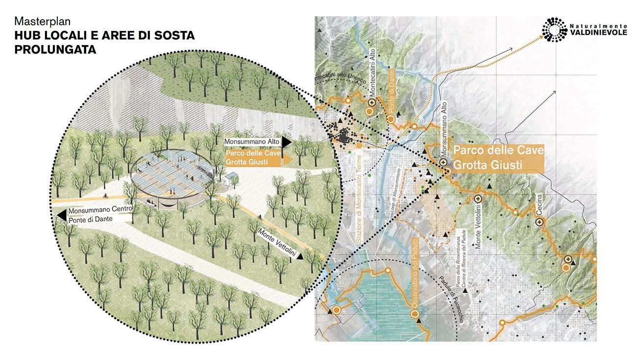
13 local hubs and extended rest areas
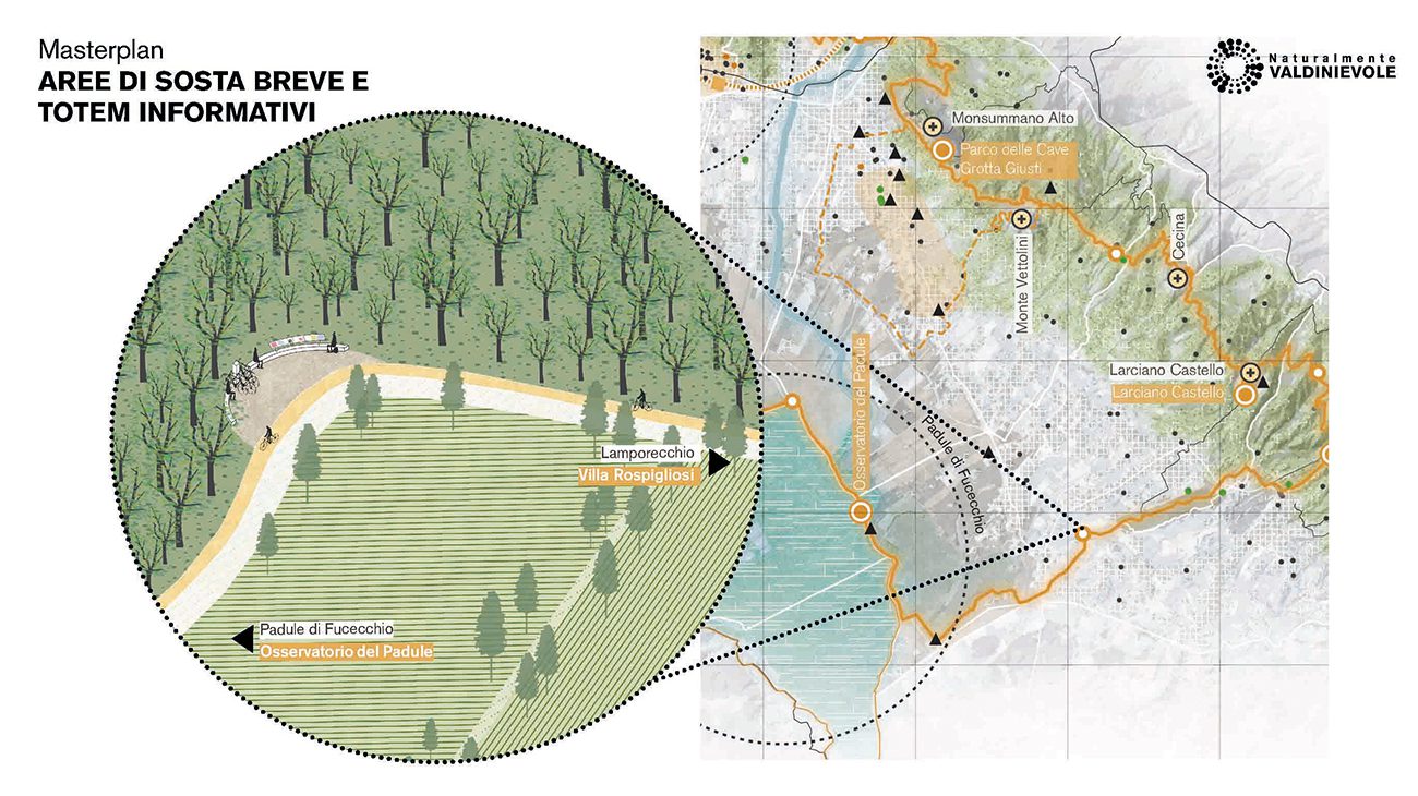
10 short stop areas
For more information: https://www.fondazionecaript.it/progetto/masterplan-della-valdinievole/